

Early Spring Fishing Trips, 2026
- Ray Sugg

- Apr 6
- 5 min read

March 9, 2026 - Oconaluftee River
It was a chilly and windy day, but I needed to catch some fish so I went anyway. I fished the roadside stretch of the "Lufty" upstream of Bradley Fork, which is smaller and easier to wade than the big water below. There were a few caddis and mayflies out, so I fished with dries and caught several small browns and rainbows on top. The browns refused to be photographed.


After lunch I decided to fish the big water from the Job Corps bridge down to the Raven Fork confluence behind the GSMNP Oconaluftee Visitor's Center. I streamer fish this at least once every spring and again in the fall. I never catch many, but I usually catch a big one. The last few years they have all been big stockers moved up from Cherokee's catch-and-release water. This time was no different as I caught a big stocked brook trout and lost another slightly bigger.


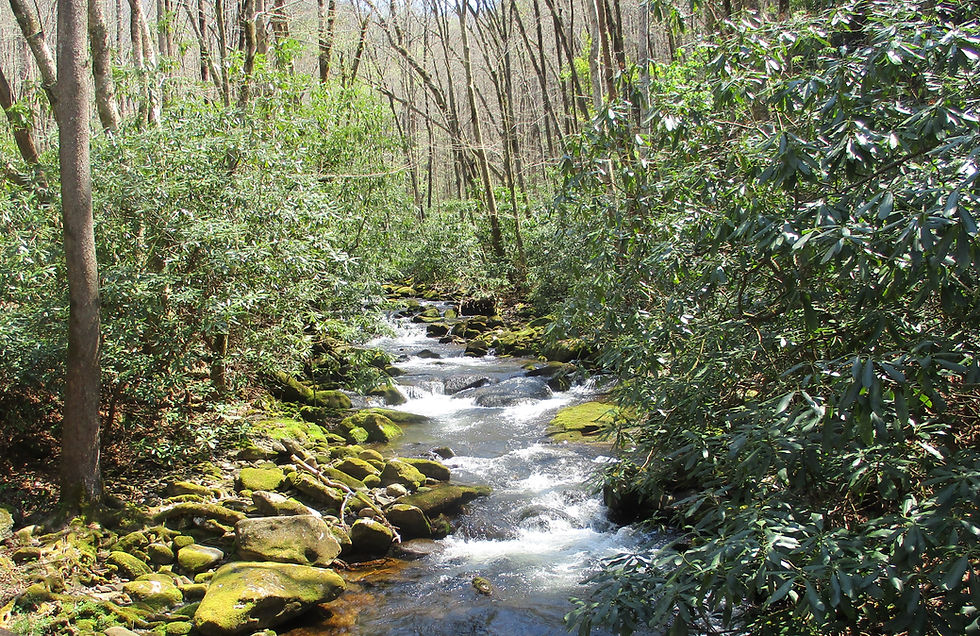
March 21, 2026 - Middle Prong
After mowing my yard for the first time this year there was still a little day left, so I headed up to the closest "Wild" designated stream, Middle Prong Pigeon river. I fished from the mouth at the Sunburst swimming hole up to the confluence of Right Hand Prong. Middle Prong is a brown trout stream below the falls. In fact it is where I caught my first ever brown trout on a fly back in 1978, but the browns were not interested in my nymph on this day. Instead, I caught stocked brookies that probably moved up from the West Fork Pigeon DH water.


March 28 - North Mills River Headwaters
Jason Jefferies and I hiked in above the old Hendersonville Watershed at the head of North Mills River to get one of my bucket list creeks. Jason has become my go-to guy for those back-country trips that I'm too old to do by myself anymore. I first camped and fished in this area back in 1980. I fished the two main headwater tributaries, Big Creek and Fletcher Creek, way back then, but I was fishing with spinners. I have since fished them with flies, plus all of the named and some unnamed tributaries of Big Creek, but I had never gone very far up Fletcher Creek. On this trip, both of us caught fish in Middle Fork Fletcher Creek, one of my bucket list creeks. As a bonus, I also caught trout in tiny Spencer Branch.


April 3, 2026 - Bubbling Spring Branch
We had a 12:30 dismissal from school on Good Friday, so after stopping by the house for a minute, I headed up to the closest brook trout water to my house - the West Fork Pigeon River headwaters. First, let's take care of some nomenclature issues. Contrary to USGS maps, the West Fork Pigeon River begins at the confluence of Middle Prong and Left-Hand Prong near the Sunburst campground. Just upstream on Middle Prong, coming in from the right, is Right-Hand Prong. The main flow that parallels highway 215 up the mountain is Left-Hand Prong (USGS wrongly calls it West Fork Pigeon). Back when I first started fishing this area, all of the water was classified as "General" (bait fishing was legal, 7 fish limit) except for Middle and Right-Hand Prongs, which were "Native" (single-hook lures only, 4 fish limit). The Left-Hand Prong was stocked down in the gorge using cables which were attached to the guardrails on highway 215. They also stocked trout at the high arch bridge and the triple arch bridge. Bubbling Spring Branch was stocked at the "cascades", at the Shining Rock Road (now known as Flat Laurel Creek Trail) crossing, and at the upper bridge on highway 215 at about 5,000 feet above sea level. Only brook trout were ever stocked in Bubbling Spring Branch, and there was also a small population of Southern Appalachian brook trout in the headwaters. All of the stocking cables, plus the old swinging bridge at the Fork Mountain Trail head were destroyed by members of "The Outlaws" motorcycle gang back in the early 1980s, and the regulations eventually changed to "Wild Trout" above the triple arch bridge (now above Tom Creek). The brookies swimming in Bubbling Spring Branch today are mostly of the "northern" variety, meaning there will not be a trout in every pocket like we find in our "spec" streams, but the average size of the trout will be much bigger than that of the Southern Appalachian variety. I fished from the trail crossing up to the upper bridge. It is a beautiful stretch that looks pristine, but is actually right beside a road. You will see a few skittish trout out in the open, but I usually catch fish by letting my fly sink to the very bottom near cover. The fish dart out, grab the fly right off the bottom and hurry back to their hidey-hole. I caught five and missed a few more, which is a great day on this stretch.


If you take the Flat Laurel Creek Trail from highway 215, shortly after you cross Bubbling Spring Branch you will come to a waterfall on an unnamed tributary that crosses the trail that is not just a blue line, it is nonexistent on most maps.

I have caught tiny brookies in this branch before, but I didn't have a date or pics so I have never counted it. There is now a good pool just above the trail crossing. When I flipped my nymph in, several fish rushed it, and I eventually caught three. Out of curiosity, I climbed above the falls where the creek splits into two tiny overgrown forks. I did not see fish in either, so the trout I caught may have come up from Bubbling Spring Branch. Regardless, I caught trout in a new blue-line creek that is actually a "no-line" creek that I will call UT Bubbling Spring Branch "Left Fork"!


Comments